 When we arrived at the trailhead, it was cold, windy, dark, and SNOWING! Yes, snowing in April at 39 degrees. We were hesitant to get out of the car to start our hike until, in an instant, the sky turned from dark to blue! The weather shifted a lot on the trail; we would hike for a bit with blue sky, and then in several minutes, it would be frigid and snow/sleeting on us!
We reached Chimney Rock pretty quickly, as it was only 1.7 miles away from the parking lot. It had a great view of the valley below, and the rocks actually did look like chimneys. The area was not too large though, and it was VERY windy, so we only stayed for a few minutes before heading on for Jamie's daring adventure.
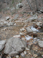
From there it was downhill, and then downhill, and then a little more downhill. (Jamie's concern about this is always that it means you'll be going UP at some point). Thanks to Alex's new iPhone app, we could track that we traveled from 2846 feet to 1695 feet in elevation. At the bottom of the mountain, we reached a stream that had lots of small falls. We also had to cross the stream several times, pouncing from rock to rock so that our toes didn't get wet. Lots of fun!
We saw several gnomes on our hike. Can you spot them?

 The rest of the hike was, as Jamie feared, uphill. But, haven eaten the breakfast of champions, Jamie and Alex reached the top without too much trouble. Caffeine can do wonders!!!!! There were lots of view on the trail of the Shenandoah Valley with the Blue Ridge Mountains in the distance. Sometimes it was hard to tell what was mountain and what was sky, they were so blue.
 After hiking 8.86 miles,according to GPS, or 9.8 miles according to the trail map, we reached out destination! Prior to this hike, our longest was less than 4 miles. We blew that out of the water thanks to Jamie's motivation! Here's to a longer hike next week! :)
Total Hike Time: 3.5 h
Difficulty: Moderate to Difficult
| Distance: | 8.86 miles | |
| Elapsed Time: | 3:13:32 | |
| Avg Speed: | 2.7 mph | |
| Max Speed: | 10.2 mph | |
| Avg Pace: | 21' 51" per mile | |
| Min Altitude: | 1,694 ft | |
| Max Altitude: | 3,005 ft | |


No comments:
Post a Comment